When Melinda Quintero moved to Greater Victoria from the U.S., she was excited to explore her new surroundings. But when it came to navigating the region’s Indigenous culture and history, she felt lost.
So instead of ‘stumbling around in the dark’, she created a map.
“I had that moment of like, gosh, I guess if you want something done, you've got to do it yourself,” said Quintero, who was unable to find information about Victoria’s many Indigenous places names in one convenient place.
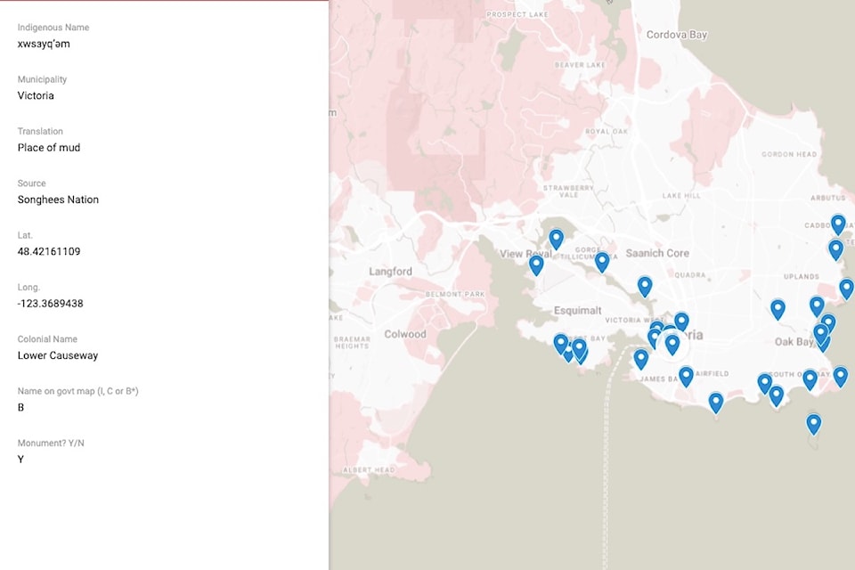
Using information readily available to the public, but scattered among various resources, Quintero has created an online database, mapping over 100 landmarks with their traditional Lekwungen place name – all of important cultural significance to the Esquimalt and Songhees First Nations.
Her starting point was the seven Indigenous monuments dotted around the Inner Harbour and surrounding areas, known as the ‘signs of Lekwungen’. One of them can be found in Beacon Hill or Mee-qan as it is known in Lekwungen, which means ‘warmed by the sun’.
“Which is a way more interesting way to think about Beacon Hill – as this place where you can lie in the grass and soak up the sun,” says the Langford resident. “That speaks more to the nature of the land than Beacon Hill, which the colonial ‘powers-that-be’ chose because it was a good place to put a beacon.”
Expecting to only find a dozen or two Lekwungen names, Quintero says she had to limit herself to landmarks between Cadboro Bay and Millstream, when she realized the extent of the information available.
“That just shows how much work and dedication Indigenous Peoples and language speakers have carried through the centuries – that these names even still exist,” she said. “The colonial story will have us believe that it doesn't exist anymore, but it's really all just there, so close to the surface … it’s like brushing the dust off.”
A student at Royal Roads University, Quintero’s map is the thesis for her master’s degree in tourism management, which she hopes to complete later this year. Currently, there are no plans for her online map to be made available to the public – as Quintero is not Indigenous, she feels that’s a decision best left in the hands of the Esquimalt and Songhees First Nations.
“I think it's a great idea, but that’s just what I think,” she says. “It's not my place to say that we need to put this out in the public .. but I do think it's pointing to a need and an opportunity to bring more of that Indigenous knowledge into our public reality.”
The map could also be an opportunity to help Victoria move away from its reputation as Canada’s ‘most British’ city; a tagline that has become stale, says Quintero, who is a former editor for a travel guidebook company in the U.S.
“We could make the story about Victoria more dynamic, more interesting … calling it ‘the most British place in Canada’, is totally erasure of Indigenous history and Indigenous presence,” she says.
“And so it turns into a larger question about representation of settler and Indigenous history, language revitalization for Indigenous Peoples and Truth and Reconciliation, it becomes quite the onion.”
With Indigenous Peoples' involvement, she hopes her project could be the starting point for the creation of a more dynamic map, one that can show how Greater Victoria looks from the Indigenous perspective and encourages a “settler reimagining of the colonial space.”
Similar to maps created for , and , which also first began life as a “settler academic project.”
“And over time, [the Nova Scotia project] developed the connections with elders and community in Nova Scotia to be able to create the dynamic map, which they were able to build over a decade,” said Quintero. “So it really feels like I'm just at the beginning, and it's exciting.”