Vancouver Island water watchers remain on alert in the wake of last summer’s extraordinary drought.
But they have found some comfort in at least one nice soft pillow.
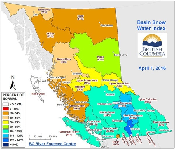
According to the posted today by the B.C. government, the Vancouver Island snowpack is right where one would expect it to be at this time of year: at 99 per cent of its normal historical level. It’s an early indication that the Island may not be facing the same extreme conditions experienced last year.
Compared to a Vancouver Island snowpack of just 15 per cent of normal on April 1, 2015, the current measurements are being welcomed as a positive, ending five straight years of decline.
B.C. River Forecast Centre section head David Campbell said weather volatility make long-term predictions impossible, but the Island is at a good starting point heading into summer.
“I think it is not as extreme as last year in terms of the snow,” he said. “It’s still been warm, but we’ve had enough accumulate on the higher elevation.”
The Wolf River snow pillow — located in the mountains northwest of Courtenay, and one of nine snowpack monitors on the Island — is reporting levels at 112 per cent of the expected normal.
For communities further south, a snowpack measuring at 78 per cent of normal is being reported from the Jump Creek snow pillow north of Cowichan Lake.
Snow levels matter more the further north you are because of the higher mountains in Strathcona Park. Further south, water supplies are more influenced by rainfall. Victoria is barely affected by snowfall at all.
Warmer conditions, but more rain led to generally higher snowpack across the island, Campbell said. The transition from snow accumulation season to melt season is already underway, about three weeks earlier than normal. River levels are expected to rise noticeably in the coming weeks.
Last year, the Island experienced what Environment Canada called an “exceptional” drought when lack of snow combined with high temperatures and drastically reduced rainfall to create a summer of extreme fire warnings and severe water restrictions for most communities.
One of the hardest-hit Island areas last year was the heritage Cowichan River, where flows were reduced to a trickle.
David Thompson, a retired hydrology technician and conservation volunteer from Shawnigan Lake made a rugged April 1 day trip to Heather Mountain, a remote recording area high in the mountains northwest of Cowichan Lake.
He trudged on snowshoes up beyond the 900-metre level to find drifts 2.25 metres deep and snow with excellent water density. After a similar trek last year found a lot of bare ground, he’s feeling much better about the coming summer.
“It’s nothing you can be sure of, but it’s going to be much better than last year,” he said. “If it comes off gradually, it will maintain lake levels. Soil moisture levels are good. We’ve had a lot of rain.”
In the Comox Valley, last year's river flows — controlled by BC Hydro — were reduced to the lowest levels in 50 years.
Comox Valley Regional District general manager of engineering services Mark Rutten said last May, June and July had the region considering implementing extreme “stage four” water restrictions for the first time ever. Rain in August and September eliminated the need, but it served as a reminder: conditions today don’t necessarily equate to conditions tomorrow.
“What is interesting in this area that is very easy to overlook is that in the summer it’s like a desert. We can go three months with what seems like no rain. Only so much water is stored water.”
Rutten said that while the snowpack already could mean enough water to last until July, residents in most jurisdictions should expect restrictions at some point, regardless. In addition to human consumption, conservation considerations must also take into account the ecology in addition to things like power generation and industrial consumption.
“You know what’s coming. You might as well prepare.”


